Microwave routes (Toyosu and Shinonome)
Original: Ryota / JJ1WTL — 499593521 · Original Japanese HTML
Published: 2023-06-04
English translation of the archived article text. The author’s first-person observations, uncertainty and later additions are preserved; this is not the research summary. Image contents are preserved as images, not silently incorporated into the translated prose.
Searching for the microwave routes from Chikura to central Tokyo, which offer lower latency than optical fibre. I could almost hear people saying, ‘Go and look there first!’ So I took the Yurikamome and explored two areas: Toyosu, where the destination data centres are, and Shinonome, where a comment had suggested there might be a relay. Saturday, June 3, after the typhoon had passed.
I seem to have narrowed things down—or perhaps not…
Targets
In the end, there were five sites:
- Shin-Toyosu Cube, AT TOKYO's Central Centre 2.
- TEPCO Toyosu Building.
- Marusada Ariake Building.
- No. 5 Inoue Building.
- Kyowa Bussan Ariake Centre.
I have added the findings to the map below, but the pieces do not quite connect.
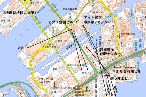
The picture beginning to emerge, with the findings included:
Shin-Toyosu Cube
https://www.google.com/maps/@35.6485344,139.7928207,183m/data=!3m1!1e3
The website of JOSADA TELECOM's parent company:
https://www.mckay-brothers.com/product-page/#Networkmap
lists the network destination as:
Tokyo - @Tokyo, CC2
That means AT TOKYO's Central Centre 2. As for where it is, the available information points, somewhat vaguely, to Shin-Toyosu Cube.
See ‘Visiting AT TOKYO, one of the world's largest data centres’:
https://cloud.watch.impress.co.jp/docs/special/757800.html
It is indeed a windowless building. This photograph is from the south, across Shinonome Canal.
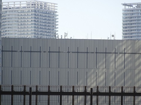
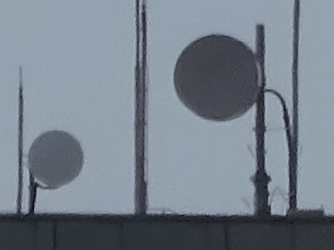
I can identify three rooftop dishes: two small and one large. They cannot be made out in the satellite image.
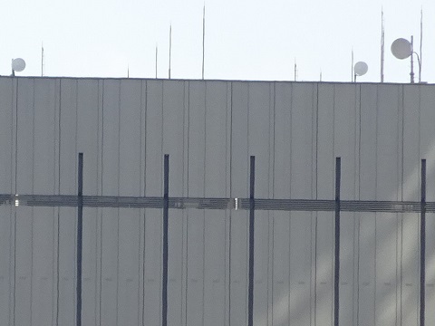
A close-up of the large dish. It seems to face Kyowa Bussan, discussed below, but I am not confident.
AT TOKYO's partner list:
https://www.attokyo.co.jp/connectivity/carrier.html
includes GTT Communications, Inc. and Josada Telecom K.K. At least those two companies should connect to an AT TOKYO data centre, although it could be a different data centre belonging to the company.
High Bar Communications and NuVo might instead connect to some other operator's data centre. Please contact the ‘I saw a dish on a data-centre roof’ department with any sightings. In Koto Ward, that is.
TEPCO Toyosu Building
Perhaps because the Boso Peninsula's hills cannot be seen directly from Shin-Toyosu Cube, the building immediately to its west also has dishes.
Looking for a tall building I could enter freely, I made my first visit to the upscale Ariake Garden. From its rooftop, three groups of dishes are visible on the roof of the round TEPCO Toyosu Building:
- At the left end, facing left, west-southwest.
- At the left end, facing this way, south by east.
- In the centre, facing this way, south-southeast.
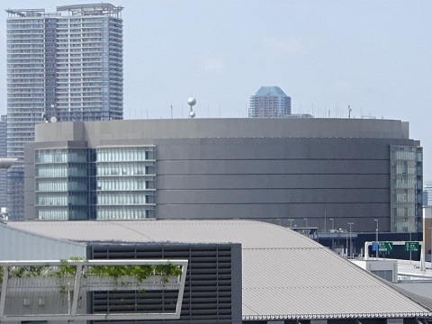
Facing west-southwest
From ground level on the west side. Could this be towards Mount Oyama?
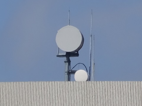
A side close-up.
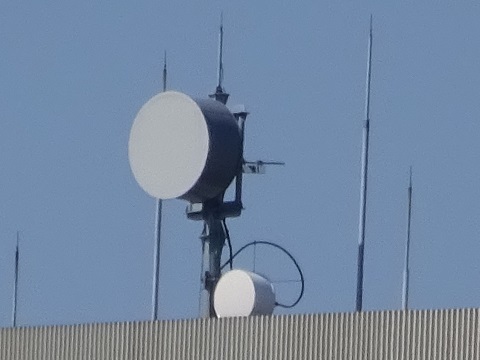
A close-up of the upper antenna.
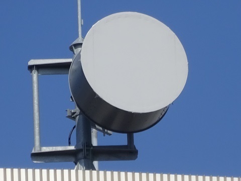
Facing south by east
It would fit if this beam were towards Marusada Ariake Building, but it seems to be pointed a little too far west.
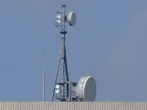
A close-up of the upper antenna.
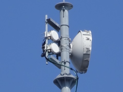
Facing south-southeast
A conventional dish without the deep body. With that combination of counterparts, could it be towards Mount Tsumori in Kyonan?
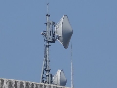
Marusada Ariake Building
https://www.google.com/maps/@35.6382021,139.7997745,44m/data=!3m1!1e3
Someone told me about this in the comments on the earlier JS2RA / JS2RB article (English translation). Thanks!
The moment I got off at Ariake Station, it was already quite conspicuous. Ha ha. At the lower right of the photograph is No. 5 Inoue Building, discussed next.
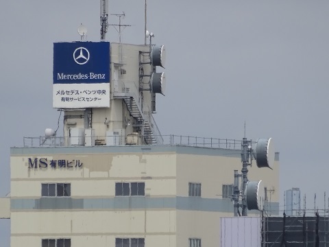
Approaching on foot.
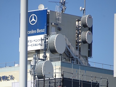
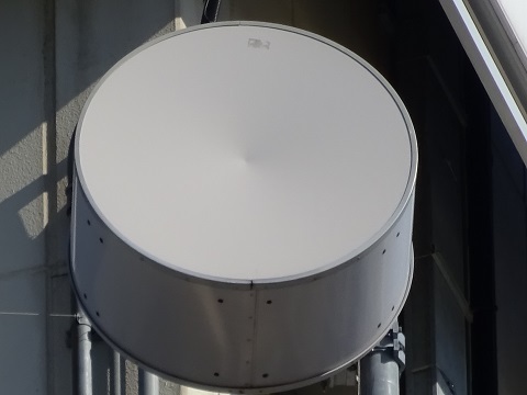
The RFcell logo shining on the antenna is evidence that this station belongs to JOSADA TELECOM: the same logo appears at Kanozan, and JOSADA is the only one of these companies whose route passes through Kimitsu. I infer that the two small dishes piggybacking here carry backhaul for mobile-phone base stations.
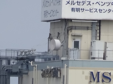
The single north-facing dish on the opposite side of the sign, viewed from Ariake Garden.
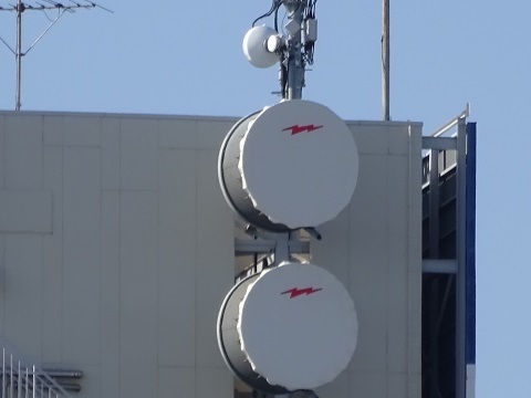
Zoomed in from the ground.
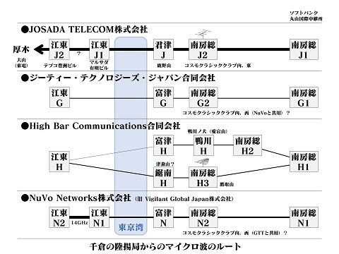
With help from the RFcell logo, I have traced quite a bit of JOSADA TELECOM's route. Combining the fieldwork with information people supplied gives the diagram below. I am still unsure about the TEPCO Toyosu Building–Marusada Ariake Building connection.
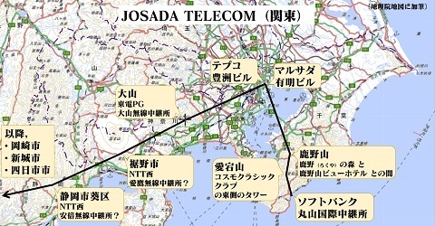
There is no well-known data centre in Yokkaichi, the endpoint, is there? Perhaps it uses microwave as far as the crossing of Ise Bay, then optical fibre beyond that.
No. 5 Inoue Building
https://www.google.com/maps/@35.6379127,139.7993943,44m/data=!3m1!1e3
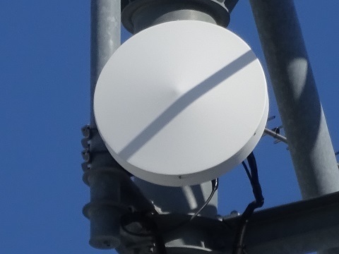
From the south. Is diagonal placement of space-diversity antennas a thing?
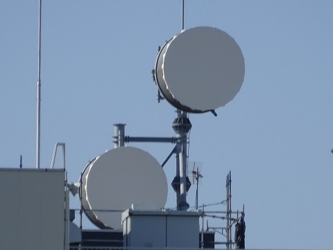
From the north.
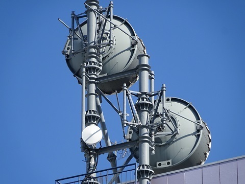
If the little dish at the base operates in the 14 GHz band, I could say definitively that it belongs to NuVo.
[Added November 10, 2024] I have identified NuVo and GTT at the Mother Farm end, using NuVo's electrical service panel. Comparing antenna shapes makes this the GTT station.
As mentioned above, Shin-Toyosu Cube's roof also has two similar small dishes.
Kyowa Bussan Ariake Centre
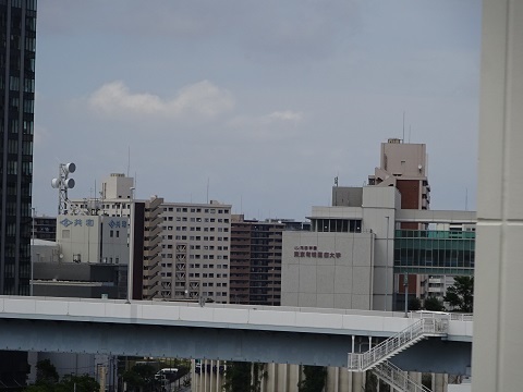
An unplanned extra site I noticed from Ariake Garden.
https://www.google.com/maps/@35.6430246,139.7966904,44m/data=!3m1!1e3
Spotted from the rooftop passage between Ariake Garden's fifth floor and its car park, at the far left of the photograph.
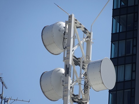
Approaching at ground level, from the south. The link across Tokyo Bay uses space diversity. Is the grey surface intended to reduce light pollution or glare?
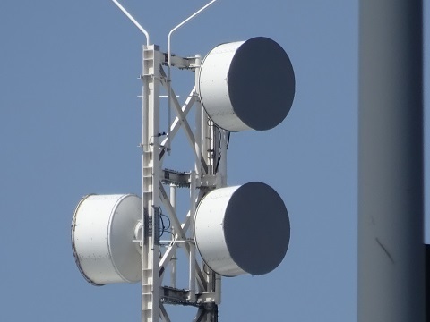
[Added November 10, 2024] I have identified NuVo and GTT at the Mother Farm end, using NuVo's electrical service panel. Comparing antenna shapes makes this the NuVo station.
Going round to the north. There is a single dish on this side. Could this be towards Shin-Toyosu Cube?
Aside: nearby relay stations
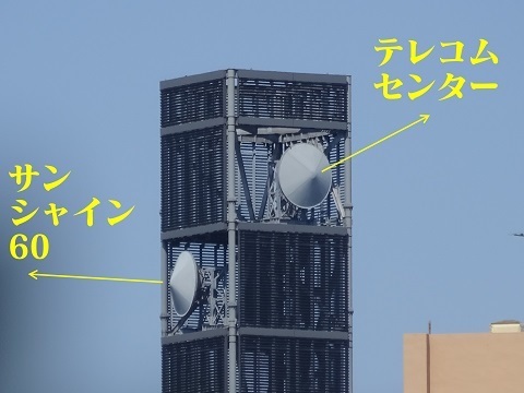
Shinonome Joint Government Building
https://www.google.com/maps/@35.6462498,139.8025011,44m/data=!3m1!1e3
Ariake-no-Oka regional disaster-response base
https://www.google.com/maps/@35.635207,139.7939696,44m/data=!3m1!1e3
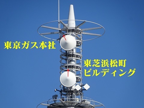
Brillia Ariake Sky Tower
No photograph. The Telecom Center–Brillia Ariake Sky Tower–IHI Headquarters–Kanegafuchi route passes through here.
- Telecom Center: https://www.google.co.jp/maps/@35.6173814,139.7798453,159m/data=!3m1!1e3
- Brillia Ariake Sky Tower: https://www.google.com/maps/@35.6363233,139.7857895,44m/data=!3m1!1e3
- IHI Headquarters: https://www.google.com/maps/@35.6591705,139.7932432,44m/data=!3m1!1e3
- Kanegafuchi: https://www.google.com/maps/@35.7351501,139.8172645,44m/data=!3m1!1e3
Below: Radio Station Information Search
Sorry if any of my proposed locations are wrong.
JOSADA TELECOM K.K.
Minamiboso — SoftBank Maruyama International Relay Station
https://www.tele.soumu.go.jp/musen/SearchServlet?pageID=4&IT=A&DFCD=0003928886ⅅ=1&styleNumber=21
- 53M5D7W, 6015 MHz, 50 mW → Cosmo Classic Club
- 53M5D7W, 6135 MHz, 50 mW → Cosmo Classic Club
https://www.google.com/maps/@35.0057699,139.9753928,45m/data=!3m1!1e3
Minamiboso — eastern tower inside Cosmo Classic Club
https://www.tele.soumu.go.jp/musen/SearchServlet?pageID=4&IT=A&DFCD=0003928887ⅅ=1&styleNumber=21
- 53M5D7W, 6275 MHz, 50 mW → SoftBank Maruyama International Relay Station
- 53M5D7W, 6395 MHz, 50 mW → SoftBank Maruyama International Relay Station
- 53M5D7W, 6275 MHz, 50 mW → Kanozan
- 53M5D7W, 6395 MHz, 50 mW → Kanozan
https://www.google.com/maps/@35.1114477,139.9555292,45m/data=!3m1!1e3
Kimitsu — Kanozan
https://www.tele.soumu.go.jp/musen/SearchServlet?pageID=4&IT=A&DFCD=0003928888ⅅ=1&styleNumber=21
- 53M5D7W, 6015 MHz, 50 mW → Cosmo Classic Club
- 53M5D7W, 6135 MHz, 50 mW → Cosmo Classic Club
- 53M5D7W, 6015 MHz, 320 mW → Marusada Transport Building
- 53M5D7W, 6135 MHz, 320 mW → Marusada Transport Building
https://www.google.com/maps/@35.2531586,139.9635836,44m/data=!3m1!1e3
Koto Ward — Marusada Transport Building
https://www.tele.soumu.go.jp/musen/SearchServlet?pageID=4&IT=A&DFCD=0003928889ⅅ=1&styleNumber=21
- 53M5D7W, 6275 MHz, 320 mW → Kanozan
- 53M5D7W, 6395 MHz, 320 mW → Kanozan
- 53M5D7W, 6275 MHz, 6.3 mW → Shin-Toyosu Cube?
- 53M5D7W, 6395 MHz, 6.3 mW → Shin-Toyosu Cube?
Koto Ward — Shin-Toyosu Cube
https://www.tele.soumu.go.jp/musen/SearchServlet?pageID=4&IT=A&DFCD=0004000033ⅅ=1&styleNumber=21
- 53M5D7W, 6015 MHz, 6.3 mW → Marusada Transport Building?
- 53M5D7W, 6135 MHz, 6.3 mW → Marusada Transport Building?
- 53M5D7W, 6015 MHz, 320 mW → Oyama
- 53M5D7W, 6135 MHz, 320 mW → Oyama
Towards Oyama:
https://www.google.co.jp/maps/@35.6477994,139.7901403,40m/data=!3m1!1e3
Atsugi — TEPCO Power Grid Oyama Radio Relay Station
https://www.tele.soumu.go.jp/musen/SearchServlet?pageID=4&IT=A&DFCD=0004293304ⅅ=1&styleNumber=21
- 53M5D7W, 6275 MHz, 320 mW → Shin-Toyosu Cube
- 53M5D7W, 6395 MHz, 320 mW → Shin-Toyosu Cube
- 53M5D7W, 6275 MHz, 320 mW → Ashitaka?
- 53M5D7W, 6395 MHz, 320 mW → Ashitaka?
Susono — NTT West Ashitaka Radio Relay Station?
https://www.tele.soumu.go.jp/musen/SearchServlet?pageID=4&IT=C&DFCD=0001503261ⅅ=1&styleNumber=21
- 53M5D7W, 6015 MHz, 320 mW → Oyama, TEPCO
- 53M5D7W, 6135 MHz, 320 mW → Oyama, TEPCO
- 53M5D7W, 6015 MHz, 320 mW → Abe?
- 53M5D7W, 6135 MHz, 320 mW → Abe?
Dishes visible here:
Aoi Ward, Shizuoka City, Shizuoka Prefecture — Abe Radio Relay Station?
https://www.tele.soumu.go.jp/musen/SearchServlet?pageID=4&IT=C&DFCD=0001503260ⅅ=1&styleNumber=21
- 53M5D7W, 6275 MHz, 320 mW → Ashitaka?
- 53M5D7W, 6395 MHz, 320 mW → Ashitaka?
- 53M5D7W, 6275 MHz, 320 mW → Okazaki
- 53M5D7W, 6395 MHz, 320 mW → Okazaki
Okazaki
https://www.tele.soumu.go.jp/musen/SearchServlet?pageID=4&IT=C&DFCD=0001503258ⅅ=1&styleNumber=21
- 53M5D7W, 6275 MHz, 320 mW → Abe?
- 53M5D7W, 6395 MHz, 320 mW → Abe?
- 53M5D7W, 6275 MHz, 100 mW → Shinshiro
- 53M5D7W, 6395 MHz, 100 mW → Shinshiro
Shinshiro
https://www.tele.soumu.go.jp/musen/SearchServlet?pageID=4&IT=C&DFCD=0001503259ⅅ=1&styleNumber=21
- 53M5D7W, 6015 MHz, 100 mW → Okazaki
- 53M5D7W, 6135 MHz, 100 mW → Okazaki
- 53M5D7W, 6015 MHz, 320 mW → Yokkaichi
- 53M5D7W, 6135 MHz, 320 mW → Yokkaichi
Yokkaichi
https://www.tele.soumu.go.jp/musen/SearchServlet?pageID=4&IT=C&DFCD=0001503257ⅅ=1&styleNumber=21
- 53M5D7W, 6015 MHz, 320 mW → Shinshiro
- 53M5D7W, 6135 MHz, 320 mW → Shinshiro
GT Technologies Japan GK
Minamiboso ① — SoftBank Maruyama International Relay Station
https://www.tele.soumu.go.jp/musen/SearchServlet?pageID=4&IT=A&DFCD=0003997873ⅅ=1&styleNumber=21
- 28M5D7W, 7450 MHz, 1.4 mW → Minamiboso ②, with different powers at the two ends
Minamiboso ②
https://www.tele.soumu.go.jp/musen/SearchServlet?pageID=4&IT=A&DFCD=0003997874ⅅ=1&styleNumber=21
- 28M5D7W, 7610 MHz, 6 mW → Minamiboso ①, with different powers at the two ends
- 28M5D7W, 7610 MHz, 6 mW → Futtsu
Futtsu
https://www.tele.soumu.go.jp/musen/SearchServlet?pageID=4&IT=A&DFCD=0003997875ⅅ=1&styleNumber=21
- 28M5D7W, 7450 MHz, 6 mW → Minamiboso ②
- 28M5D7W, 6835 MHz, 45 mW → Koto Ward
Mother Farm? It could also be NuVo.
https://www.google.co.jp/maps/@35.2464153,139.9359888,40m/data=!3m1!1e3
With this station, I feel that the southern beam does not fit:
https://www.google.co.jp/maps/@35.2478598,139.9365334,40m/data=!3m1!1e3
Koto Ward
https://www.tele.soumu.go.jp/musen/SearchServlet?pageID=4&IT=A&DFCD=0003997876ⅅ=1&styleNumber=21
- 28M5D7W, 6675 MHz, 45 mW → Futtsu
High Bar Communications GK
Minamiboso ① — SoftBank Maruyama International Relay Station
https://www.tele.soumu.go.jp/musen/SearchServlet?pageID=4&IT=A&DFCD=0004121749ⅅ=1&styleNumber=21
- 28M5D7W, 6615 MHz, 7.9 mW → Minamiboso ②
- 28M5D7W, 6585 MHz, 20 mW → Minamiboso ③
Minamiboso ②
https://www.tele.soumu.go.jp/musen/SearchServlet?pageID=4&IT=A&DFCD=0004121750ⅅ=1&styleNumber=21
- 28M5D7W, 6775 MHz, 7.9 mW → Minamiboso ①
- 28M5D7W, 6745 MHz, 7.9 mW → Kamogawa
Kuroiwa, Wada-cho. East of the NTT-related tower?
https://www.google.co.jp/maps/@35.0614164,139.9882158,40m/data=!3m1!1e3
Minamiboso ③ — Mount Takatori
https://www.tele.soumu.go.jp/musen/SearchServlet?pageID=4&IT=A&DFCD=0004121754ⅅ=1&styleNumber=21
- 28M5D7W, 6745 MHz, 20 mW → Minamiboso ①
- 28M5D7W, 6775 MHz, 7.9 mW → Mount Tsumori, Kyonan?
Kamogawa — Kamogawa-no-Inu station, Mount Atago
https://www.tele.soumu.go.jp/musen/SearchServlet?pageID=4&IT=A&DFCD=0004121751ⅅ=1&styleNumber=21
- 28M5D7W, 6585 MHz, 7.9 mW → Minamiboso ②
- 28M5D7W, 6675 MHz, 79 mW → Futtsu
Futtsu
https://www.tele.soumu.go.jp/musen/SearchServlet?pageID=4&IT=A&DFCD=0004121752ⅅ=1&styleNumber=21
- 28M5D7W, 6835 MHz, 79 mW → Kamogawa
- 19M0D7W, 7545 MHz, 79 mW → Koto Ward
Kyonan — Mount Tsumori?
https://www.tele.soumu.go.jp/musen/SearchServlet?pageID=4&IT=A&DFCD=0004121755ⅅ=1&styleNumber=21
- 28M5D7W, 6615 MHz, 7.9 mW → Minamiboso ③
- 28M5D7W, 6585 MHz, 160 mW → Koto Ward, with different powers at the two ends
https://www.google.com/maps/@35.1391888,139.9297278,45m/data=!3m1!1e3
https://yamareco.info/modules/yamareco/upimg/384/3842714/98fdca32d5b2dc06b451a23c5d0cb5b7.JPG

Koto Ward
https://www.tele.soumu.go.jp/musen/SearchServlet?pageID=4&IT=A&DFCD=0004121753ⅅ=1&styleNumber=21
- 19M0D7W, 7705 MHz, 79 mW → Futtsu
- 28M5D7W, 6745 MHz, 200 mW → Kyonan, with different powers at the two ends
NuVo Networks K.K.
Formerly Vigilant Global Japan.
Minamiboso ①
https://www.tele.soumu.go.jp/musen/SearchServlet?pageID=4&IT=A&DFCD=0004176359ⅅ=1&styleNumber=21
- 36M5D7W, 6670 MHz, 40 mW → Minamiboso ②?
Minamiboso ②
https://www.tele.soumu.go.jp/musen/SearchServlet?pageID=4&IT=A&DFCD=0004176360ⅅ=1&styleNumber=21
- 36M5D7W, 6830 MHz, 40 mW → Futtsu and Minamiboso ①?
Futtsu
https://www.tele.soumu.go.jp/musen/SearchServlet?pageID=4&IT=A&DFCD=0004176361ⅅ=1&styleNumber=21
- 36M5D7W, 6670 MHz, 40 mW → Minamiboso ②?
- 36M5D7W, 7695 MHz, 200 mW → Koto Ward ①, with different powers at the two ends
Koto Ward ①
https://www.tele.soumu.go.jp/musen/SearchServlet?pageID=4&IT=A&DFCD=0004277212ⅅ=1&styleNumber=21
- 53M5D7W, 14.43 GHz, 320 μW → Koto Ward ②
- 36M5D7W, 7535 MHz, 130 mW → Futtsu, with different powers at the two ends
Koto Ward ②
https://www.tele.soumu.go.jp/musen/SearchServlet?pageID=4&IT=A&DFCD=0004277213ⅅ=1&styleNumber=21
- 53M5D7W, 14.9 GHz, 320 μW → Koto Ward ①